Cruise Rates & Dates - The Ship - Technical Specifications - Deck
Plans - Photo Gallery
Ship |
Ushuaia-Punta Arenas |
Punta Arenas-Ushuaia |
Stella Australis |
|
|
 Print/Download Ushuaia-Punta Arenas 5-Day Cruise Sample Itinerary V1 (185K PDF)
Print/Download Punta Arenas-Ushuaia 5-Day Cruise Sample Itinerary V1 (198K PDF)
(PDFs open in new windows & require Adobe Reader)

|
Click map to enlarge (opens in new window) |
Day 1, Sat: Depark Ushuaia (D) Check in at 409 San Martín Ave. in downtown Ushuaia between 10:00 a.m. – 5:00 p.m.) on the day of your cruise departure. Board the M/V Stella Australis at 6:00 p.m. After a welcoming toast and introduction of captain and crew, the ship departs for one of the most remote corners of planet Earth. During the night we traverse the Beagle Channel and cross from Argentina into Chilean territorial waters. The lights of Ushuaia disappear as we turn into the narrow Murray Channel between Navarino and Hoste islands.
Day 2, Sun: Cape Horn and Walaia Bay (B, L, D) Around the break of dawn, M/V Stella Australis crosses Nassau Bay and enters the remote archipelago that comprises Cape Horn National Park.  Weather and sea conditions permitting, you will go ashore on the windswept island that harbors legendary Cape Horn (Cabo de Hornos). Discovered in 1616 by a Dutch maritime expedition – and named after the town of Hoorn in West Friesland – Cape Horn is a sheer 425-meter (1,394-foot) high rocky promontory overlooking the turbulent waters of the Drake Passage. For many years it was the only navigation route between the Pacific and Atlantic, and was often referred to as the ‘End of the Earth.’ The park was declared a World Biosphere Reserve by UNESCO in 2005. The Chilean navy maintains a permanent lighthouse on the island, staffed by a lightkeeper and his family, as well as the tiny Stella Maris Chapel and modern Cape Horn Monument (currently awaiting repair after being damaged by fierce winds).
 Sailing back across Nassau Bay, you anchor at fabled Wulaia Bay, one of the few places in the archipelago where the human history is just as compelling as the natural environment. Originally the site of one of the region’s largest Yámana aboriginal settlements, the bay was described by Charles Darwin and sketched by Captain FitzRoy in the 1830s during their voyages on HMS Beagle. This area is also renowned for its mesmerizing beauty and dramatic geography. After a visit to the Australis-sponsored museum in the old radio station – which is especially strong on the Yámana people and European missionaries in the area – passengers have a choice of three hikes (of increasing degrees of difficulty) that ascend the heavily wooded mountain behind the bay. On all of these you stroll through an enchanted Magellanic forest of lengas, coigües, canelos and ferns to reach panoramic viewpoints overlooking the bay.)
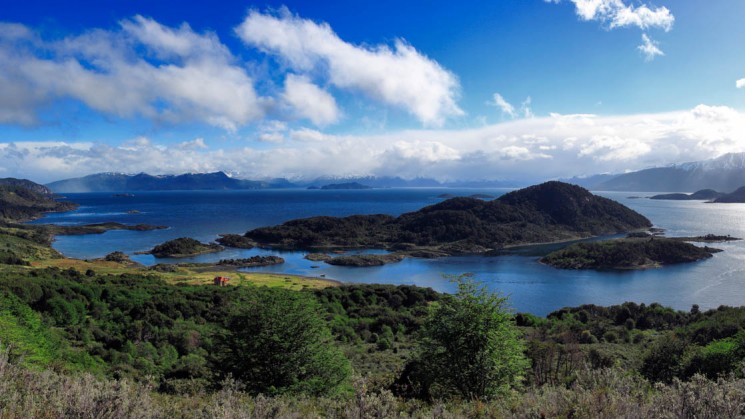
Day 3, Mon: Pía Glacier – Garibaldi Glacier (B, L, D)  You continue overnight around the western end of Tierra del Fuego via the very narrow Gabrial Channel, Magdalena Channel and Cockburn Channel.After rounding the remote Brecknock Peninsula, Stella Australis tacks eastward and enters the Beagle Channel again.By morning you are entering Pia Fjord and boarding the Zodiacs for a shore excursion to Pia Glacier.After disembarking you take a short hike to gain a panoramic view of the spectacular glacier, which extends from the mountaintops down to the sea.Or you can opt for a longer much more difficult walk up a lateral moraine of the old Pia Glacier.No one knows for certain how the hulking mass of snow and ice got its feminine moniker, but one theory says it was named for Princess Maria Pia of Savoy (1847-1911), daughter of the Italian king.
 Making your way further west along the Beagle Channel, you enter another long fjord and drop anchor near Garibaldi Glacier for another shore excursion. Garibaldi is one of only three glaciers in Patagonia gaining mass rather than staying the same or slowly shrinking.This time you hike through virgin Magellanic forest to a glacial waterfall, a towering wall of ferns and moss, and spectacular viewpoints looking down on the glacier and fjord. The walk is demanding – very steep, negligible trail, rough footing – and not for everyone. For those who choose to stay onboard, the captain will point the bow towards the beautiful sky blue Garibaldi Glacier so everyone can enjoy the panoramic view from the upper decks.
Day 4, Tue: Agostini Sound – Águila Glacier – Cóndor Glacier (B, L, D) You sail through the Cockburn Channel early in the morning and enter Agostini Sound. From there it is possible to see the glaciers that descend from the middle of the Darwin Mountain Range – some of them reaching the water. This morning you will disembark and go for an easy walk around a lagoon, which was formed by the melting of the Águila Glacier. You will reach a spot right in front of that glacier with stunning views. In the afternoon,youapproach the Condor Glacier via Zodiac – and hopefully see some of the abundant Andean Condors in the area.
Day 5, Wed: Magdalena Island - Punta Arenas (B) After an overnight cruise through Magdalena Channel and back into the Strait of Magellan, you anchor off Magdalena Island*, which lies about halfway between Tierra del Fuego and the Chilean mainland.  Crowned by a distinctive lighthouse, the island used to be an essential source of supplies for navigators and explorers and is inhabited by an immense colony of Magellanic penguins. At the break of dawn, weather permitting, you go ashore and hike a path that leads through thousands of penguins to a small museum lodged inside the vintage 1902 lighthouse. Many other bird species are also found on the island. In September and April – when the penguins dwell elsewhere – this excursion is replaced by a ride aboard Zodiacs to Marta Island to observe South American sea lions. After a short cruise south along the strait, disembarkation at Punta Arenas is scheduled for around 11:30 a.m. (B)
*Camera extension poles are prohibited on Magdalena Island.
|
Click map to enlarge (opens in new window) |
Day 1, Tue: Depart Punta Arenas (D) Check in at 1385 O’Higgins Street (Arturo Prat Port) in Punta Arenas between 1:00 p.m.-5:00 p.m. on the day of your Australis cruise departure. Board the M/V Stella Australis at 6:00 p.m. After a welcoming toast and introduction of captain and crew, the ship departs for one of the remotest corners of planet Earth. During the night you cross the Strait of Magellan and enter the labyrinth of channels that define the southern extreme of Patagonia. The twinkling lights of Punta Arenas gradually fade into the distance as you enter the Whiteside Canal between Darwin Island and Isla Grande de Tierra del Fuego.
Day 2, Wed: Ainsworth Bay - Tuckers Islets (B, L, D) By dawn the ship is sailing up Admiralty Sound (Seno Almirantazgo), a spectacular offshoot of the Strait of Magellan that stretches nearly halfway across Tierra del Fuego. The snowcapped peaks of Karukinka NaturalPark stretch along the north side of the sound, while the south shore is defined by the deep fjords and broad bays of Alberto de Agostini National Park.  You go ashore at Ainsworth Bay, which harbors copious bird life and a colony of southern elephant seals which can sometimes be spotted from the Zodiacs. Two guided excursions are available: one is along the edge of a stream, peat bog and beaver habitat to a waterfall-and-moss-covered rock face tucked deep inside a pristine sub-polar forest; the other is a more strenuous hike along the crest of a glacial moraine. Both afford views of Marinelli Glacier and the Darwin Mountains.
Leaving the Ainsworth Bay tour behind, you sail west along the sound to the Tucker Islets. After lunch, you board the Zodiacs again for a close-up view of the Magellan penguins that inhabit the tiny islands. More than 4,000 penguins use Tucker as a place to nest, give birth and nurture their chicks. Many other bird species also frequent the area including king cormorants, oystercatchers, Chilean skuas, kelp geese, dolphin gulls, eagles and even the occasional Andean condor. In September and April – when the penguins live elsewhere – this excursion is replaced by a short walk to a glacier at nearby stunning Brookes Bay.
 Day 3, Thursday: Pia Glacier - Glacier Alley (B, L, D) You sail overnight around the western end of Tierra del Fuego via the very narrow Gabrial Channel, Magdalena Channel and Cockburn Channel. After rounding the remote Brecknock Peninsula, M/V Stella Australis tacks eastward and enters the Beagle Channel again. By morning you head for Pia Fjord and boarding the Zodiacs for a Pia Glacier tour. After disembarking you take a short hike to gain a panoramic view of the spectacular glacier, which extends from the mountaintops down to the sea. Or you can opt for a longer, much more difficult walk up a lateral moraine of the old Pia Glacier. No one knows for certain how the hulking mass of snow and ice got its feminine moniker, but one theory says it was named for Princess Maria Pia of Savoy (1847-1911), daughter of the Italian king. Back onboard the ship, you continue east along the Beagle Channel through an area called Glacier Alley. Living up to its name, the passage features a number of impressive tidewater glaciers flowing down from the Darwin Mountains and Darwin Ice Sheet on the north shore. Most of them named after European countries – Holland, Italy, Germany, Spain and France.
Day 4, Friday: Wulaia Bay - Cape Horn (B, L, D) During the early morning you navigate the narrow Murray Channel between Navarino and Hoste islands and drop anchor at historic Wulaia Bay, one of the few places in the archipelago where the human history is just as compelling as the natural environment. Originally the site of one of the region’s largest Yámana aboriginal settlements, the bay was described by Charles Darwin and sketched by Captain Fitz Roy in the 1830s during their voyages on the HMS Beagle. This area is also renowned for its mesmerizing beauty and dramatic geography. After a visit to the Australis-sponsored museum in the old radio station – which is especially strong on the Yámana people and European missionaries in the area – passengers have a choice of three hikes (of increasing degrees of difficulty) that ascend the heavily wooden mountain behind the bay.  On all of these you will be strolling through an enchanted Magellan forest of lengas, coigües, canelos, ferns, and other endemic fauna to reach a panoramic viewpoint overlooking the bay. Before leaving Wulaia Bay, drop something into the wooden mail barrel inside the museum – letters or postcards meant to be hand delivered by future travelers – an ancient mariner tradition revived by Australis.
In the afternoon you cruise across Nassau Bay into the remote archipelago that includes Cape Horn National Park. Weather and sea conditions permitting, you will go ashore on the windswept island that harbors legendary Cape Horn (Cabo de Hornos). Discovered in 1616 by a Dutch maritime expedition – and named after the town of Hoorn in West Friesland – Cape Horn is a sheer 425-meter (1,394-foot) high rocky promontory overlooking the turbulent waters of the Drake Passage. For many years it was the only navigation route between the Pacific and Atlantic, and was often referred to as the "End of the Earth." The park was declared a World Biosphere Reserve by UNESCO in 2005. The Chilean navy maintains a permanent lighthouse on the island, staffed by a lightkeeper and his family, as well as the tiny Stella Maris Chapel and modern Cape Horn Monument
Day 5, Sat: Arrive Ushuaia (B) You sail into Argentine waters and dock in Ushuaia in the morning, the world's southernmost city. Arrival at 8:30 a.m. or 9:30 a.m. according to date of departure.

Ushuaia - "The Southermost City in the World"